Last updated on
2nd March 2021
Metropolitan Line
A selection of diagrams showing the signalling arrangements for sections of the Metropolitan Line at different times throughout its history.

|
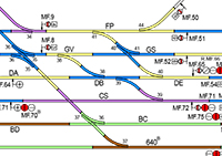
Harrow to Amersham
1962 A large diagram showing details of the signalling between Harrow on the Hill and Amersham and Chesham just after completion of the four tracking scheme between Harrow and Watford South Junction and the extension of electrification from Rickmansworth to Amersham. Make sure you zoom in to see all the detail. |
|
|
Four Tracking Harrow to Moor Park A set of diagrams showing each major stage in the 1961/62 scheme to provide four tracks between Harrow North Junction and Watford South Junction on the Metropolitan Line. Make sure you zoom in to see all the detail. |
|
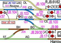
Harrow On The Hill 1962 & 1996 A pair of diagrams showing the signalling in the Harrow on the Hill area as it was in 1962, just after the completion of the four tracking scheme between Harrow North Junction and Watford South Junction, and 1996, long after the rationalisations caused by the closure of the goods yard. There are three signal cabins at Harrow. Two, Harrow North and Harrow South, are controlled remotely from the third, located at the station. Point and signal numbers are colour coded to indicate to which cabin controls it. Make sure you zoom in to see all the detail. |

|
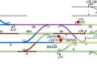
Rickmansworth 1953, 1961 & 1996 A set of diagrams showing the various changes at Rickmansworth since the current Signal Cabin opened in 1953. |

|
Uxbridge Branch 1949, 1975,1994, 2018 A series of diagrams showing details of the signalling along the Uxbridge Branch of the Metropolitan Line in 1949, 1975, 1994 & 2018. You will need to zoom in to see all the detail. |
|
Metropolitan Railway 1933 A very large diagram showing virtually all of the Metropolitan Railway as it was in 1933. It reaches from Aldgate to South Kensington, Stanmore, Uxbridge, Watford, Chesham and Great Missenden (beyond Amersham). Make sure you zoom in to see all the detail. |

|
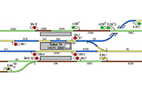
Wembley Park 1924 A diagram showing the arrangements at Wembley Park after the alterations made in 1923 for the Empire Exhibition. Also included is a locking table. Make sure you zoom in to see all the detail. |

|
Kings Cross to Aldgate 1958 A large of diagram showing the signalling arrangements between Kings Cross and Aldgate in 1958. It also includes the City Widened Lines and extracts of the area at other dates. |
|
Baker Street SCC 2005 The southern section of the Metropolitan Line was signalled from the Metropolitan and Jubilee SCC at Baker Street. This diagram shows the whole SCC control area as it was circa 2005. It also shows the Jubilee Line Extension from Green Park to Stratford (controlled from Neasden SCC) and the Bakerloo Line (controlled from the Bakerloo SCC at Baker Street). Make sure you zoom in to see all the detail. |
|
Elephant & Castle to Queens Park and Stanmore 1941 A large diagram showing the details of signalling on the Bakerloo Line in 1941 between Elephant & Castle and Queens Park or Stanmore. This follows the completion of the re-signalling of most of the original Bakerloo Line along with the opening of the extension to Stanmore. This diagram also shows the signalling on the Metropolitan Line from Preston Road to Lords. Make sure you zoom in to see all the detail. |

|
Baker Street 1987 & 2010 Two diagrams showing the arrangements before and after the recent alterations to lengthen some of the platforms at Baker Street (Met). |
Most of the diagrams are in PDF format and to open them you will need Adobe Acrobat Reader. If you do not already have this it can be downloaded from the Adobe Website.