Last updated on
10th March 2023

Hammersmith & City Line
A selection of diagrams showing the signalling arrangements for sections of the Hammersmith & City Line at different times throughout its history.

|
Whitechapel to Upminster 1936 A large diagram showing the signalling on the east of the District Line between Whitechapel and Upminster in 1936. Today the Hammersmith and City Line runs over this section as far as Barking. Make sure you zoom in to see all the detail. |
|
Whitechapel to Upminster 1960 A large diagram showing the signalling on the east of the District Line between Whitechapel and Upminster in 1960. Today the Hammersmith and City Line runs over this section as far as Barking. Make sure you zoom in to see all the detail. |
|
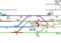
Hammersmith Branch (Hammersmith to Edgware
Road) 1951 The signalling on the Hammersmith Branch was modernised between 1949 and 1951. This large diagram shows the arrangements just after this work was completed, and also shows how the branch threaded its way through the maze of lines approaching Paddington station. Make sure you zoom in to see all the detail. |

|
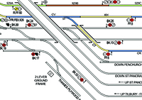
Kings Cross to Whitechapel 1958 A large of diagram showing the signalling arrangements between Kings Cross and Whitechapel in 1958. It also includes the City Widened Lines and extracts of the area at other dates. |
|
Metropolitan Railway 1933 A very large diagram showing virtually all of the Metropolitan Railway as it was in 1933. It includes the Paddington to Liverpool Street section of the Hammersmith & City Line. Make sure you zoom in to see all the detail. |
|
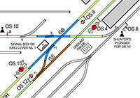
Baker Street SCC 2005 The section of the Hammersmith & City Line from Baker Street to Aldgate East was signalled from the Metropolitan and Jubilee SCC at Baker Street. This diagram shows the whole SCC control area as it was circa 2005. It also shows the Jubilee Line Extension from Green Park to Stratford (controlled from Neasden SCC) and the Bakerloo Line (controlled from the Bakerloo SCC at Baker Street). Make sure you zoom in to see all the detail. |

|
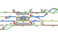
Baker Street 1987 & 2010 Two diagrams showing the arrangements before and after the recent alterations to lengthen some of the platforms at Baker Street (Met). |
Most of the diagrams are in PDF format and to open them you will need Adobe Acrobat Reader. If you do not already have this it can be downloaded from the Adobe Website.